WALDRINGFIELD HISTORY GROUP presents
THE WALDRINGFIELD HISTORY WALK
Presenter: Gareth Thomas Illustrator: Jackie Brinsley
➢ The walk starts at Waldringfield Village Hall where parking is free.
➢ The walk is just under 5 kilometres and is likely to take about 2½ hours.
➢ There are sections where the ‘going’ may be muddy.
➢ The walk is circular and returns the walker to the village hall car park.
➢ The ‘Maybush’ is situated about half-way round.
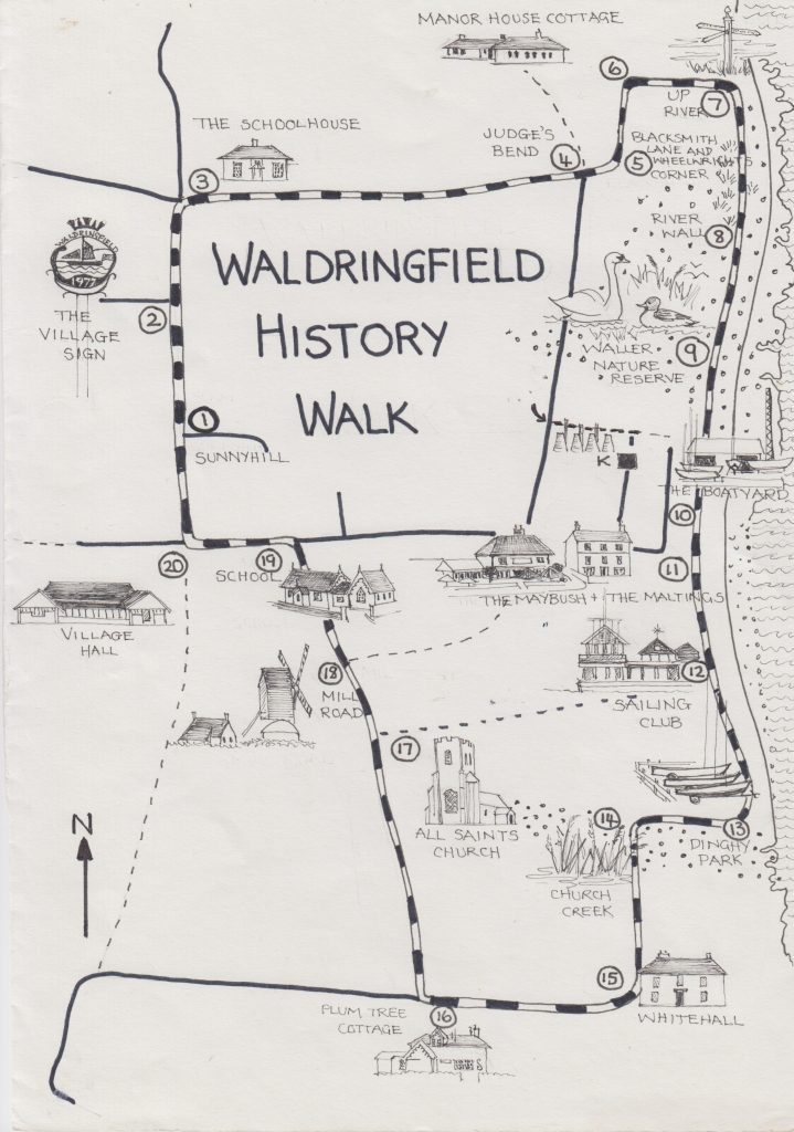
➢ There are twenty recommended stopping points as shown on the map
Whilst there are no dangerous elements to this walk (apart from walking along public highways) we have to remind participants that they undertake the walk entirely at their own risk.
In 2020 the Waldringfield History Group (est.2007) published a book entitled “Waldringfield – A Suffolk Village beside the River Deben.” In that book, much of this walk was described as it might have been
i. in 1348, pre river walls
ii. in 1881, the height of the industrial revolution
iii. in June 1944 just prior to D-day and
iv. in 1971 at the start of what one might describe as the touristic revolution.
Most of what you read here may be found somewhere in those 300 pages. The River Deben and its environs change from day to day, hour to hour and, for many, there is an aura to it which makes one wonder what it must have been like in the past.
We are four miles from Sutton Hoo (as the crow flies) – we were once part of the Thames estuary, we have evidence of iron and bronze age settlements, of Roman habitation and the days of the Anglo-Saxons and the Vikings. Kings of England, Edward III and Henry VIII particularly, built ships just four miles down-river at Kingsfleet and then set forth either to trade with France or to invade it. The nineteenth century brought industry -first in the form of coprolite mining and then in the form of a cement works with its twelve kilns and new houses for some of its employees. The twentieth century brought wars and all that goes with them, then boatbuilding and tourism and the foundation of a very successful sailing club.
Waldringfield is an agricultural village – now arable but, in the past, mixed farming with sheep and cows. Nevertheless, at its heart – it’s raison d’etre – is the River Deben. It is one of the very few practical landing places on the Deben. A third of this 4.5 kilometre walk will be along the river walls but, wherever we are in the village, the river will never be far away
The river itself is approximately 33 miles long – it winds its way from its source near Debenham, past Ufford where it currently becomes tidal, past Woodbridge where the first tide-mill operated in 1170, and down to its opening into the North Sea at Felixstowe Ferry. A crow, making the same journey, would cover just 19 miles – so, yes, it is a winding river, recognised internationally for its wetlands, its fenland and its saltmarshes. On early maps the river is denoted as the ‘Ocean’.
JB 2026
To download a pdf copy of the walk either scan the QR code below or
click here

Let us proceed
Please ensure that you have a copy of the map available but please do not attempt to use it to find your way back – it’s not to scale! Head away from the Village Hall, down School Road, as if you were going to Ipswich.
STOP 1: The turning into Sunny Hill, where there is space to stop and observe without getting in the way of traffic.
There are three or four substantial late Victorian /early Edwardian houses at this end of School Road – built in 1900 to 1903 (as evidenced by the dates above their doors), they represent the prosperity which was evident in Waldringfield at that time. There was a large Cement Works down by the river and that required an effective and flourishing infrastructure. The village carrier, for instance, lived in one of these houses. The local landowner who developed Sunny Hill gave land on the corner opposite the school for use by the community. Today there is a dog-free, recently refurbished children’s playground and a tennis court, also recently resurfaced.
You will see that there is a major dip in School Road, of which I will say more when we reach the Village sign. As we begin to descend take a look to your right – there you will see a steep embankment which was once a site of coprolite mining – again, I will say more when we reach the village sign.
STOP 2: The Village Sign. Again, there is space to stand out of the way of traffic.
You are standing now in what used to be a pronounced valley, with several tributaries coursing down to the edge of the River Deben and forming a delta which emptied into Waldringfield Bay at what is now called Sandy Lane, previously called Lower Road. The bay no longer exists because river walls, built between the 15th and 17th centuries, have changed the shape of the river.
The first written evidence of Waldringfield, in the 9th century, suggests that it was probably two manors – one to the north, Preston, with no sign ever of a parish church but archaeological evidence of an old manor house – and one to the south, Hilton, with a parish church and archaeological evidence of Romans and earlier settlements.
This valley separated the manors with the Manor of Preston to the north and the Manor of Hilton behind you, to the south.
THE SIGN was commissioned in 1977, the year of the late Queen Elizabeth’s Silver Jubilee. It was ‘opened’ by the then Lord Mayor of London, Sir Peter Vanneck, who had a newly built holiday home opposite the village shop which was on the corner of Deben Lane, about 200 yards up the road from the Maybush.
The sign was designed by Audrie Fitzjohn, a local resident, artist and keen sailor who started a history group and arranged interviews with local people, much as we do today. The sign was cast at the forge in Kirton; it depicts the river with a working barge and a plesiosaurus, all under a naval crown. Working barges were first used in Waldringfield for taking hay to London and returning with horse muck for the fields. Then, in the mid 19th century, they were used to take coprolite to Ipswich for Fison’s new fertiliser production. Coprolite is the fossilised dung of dinosaurs – it is rich in phosphates and can be mined from 40 foot deep pits such as the one you have just seen behind Mickey’s Field on the other side of the road from here. Hence, perhaps, the plesiosaurus. (I say ‘perhaps’ because the plesiosaurus was an aquatic reptile – (the modern equivalent is the turtle) – it was not a dinosaur but it existed alongside dinosaurs. It seems Audrey Fitzjohn was keen to accentuate the prehistoric history of Waldringfield.
Dinosaurs lived 66 to 208 million years ago. They were huge. The adult plesiosaurus was relatively small, being ‘only’ 3.5 metres long and 1 metre high with a mass of 500 kg.
From here we will continue along School Road and on to Fishpond Road which, once upon a time, was the main street of the village. Please proceed carefully in single file on the right- hand side of the road as you approach the bend and cross-roads.
STOP 3: The right turn into Fishpond Road
Just into Fishpond Road you can stop to take in an aura of 1881. The roads were merely tracks. School Road led to the new school, Ipswich Road led to the big town, rarely visited, Woodbridge Road led to Martlesham, and Fishpond Road, the main street of the village, led to the river past the Rectory, past several farms and old cottages, and past the wheelwright and blacksmiths.
Most Suffolk villages are laid out as long straight lines, but as you may see from the map Waldringfield has evolved into a rectangular arrangement, with All Saints’ Church almost in the middle of one long edge (17) and the Maybush (11) almost in the middle of the opposite side, beside the river. Two large late 18th century, early 19th century houses are on the opposing short sides ([between 3 and 4] and 15). The numbers refer to ‘stops’ on the map
You are standing opposite Old School House, built in 1864. With the building of the new school in 1874, the old school-house became superfluous. However, by 1881 it had become the Reading room for Cement workers and their families who were able to use it for the princely sum of a penny a week.
Looking to your left over the cross-roads you can see a pair of Pretyman Cottages, built for agricultural workers in the 19th century. The annex to the left of the furthest cottage was the first village Post Office. Beyond the ‘Pretymans’ is Low Farm, the first of several farms between here and the river. There are three pairs of workers cottages in Woodbridge Road, just in sight if you take a few paces to your left.
Before you leave this spot just imagine, thirty years on from 1881, King George V hunting on land between here and Waldringfield Heath – he would arrive at Nacton Station, stay at Orwell Park and hunt in Waldringfield.
As you begin to walk along Fishpond Road you will see on your left what might be called the dowager house – it was built to accommodate the rector’s mother in her widowhood – at a respectable distance from the Rectory which was further along the road. This house is the family home of the late co-founder of our History Group, Joe Clark. For several years it was said that he had discovered some photographic glass slides in his attic and had taken them to be digitalised in order to share them with the village. It was some years later that his wife, Kit, hearing this for the first time said “But we haven’t got an attic’
You are encouraged to look up when you pass buildings because often you will see clues as to the age of the building or you will see beautifully carved bargeboards similar to those seen on this house. The shutters are said to have been made from old box pews.
Two hundred yards or so, further along Fishpond Road, again on your left, you will see Rivershall – a large house built in the early 1800s for the Rector. It was The Rectory. The Rector’s wife, Mrs Suart, thought the road was too near the house, so she had the road moved – hence a wide bend in the road.
One Thomas Henry Waller was installed in the Rectory in 1862 following a curacy at St Matthews in Ipswich. He had married Jayne, née Pretyman of Ramsholt, in 1856. They went on to have eleven children, the youngest of whom, Arthur, succeeded him as Rector after 47 years. Arthur’s son, Trevor and grandson, John, also served sequentially as Rectors of Waldringfield and between the four of them they covered 151 years.
On the right side of the lane as you are about to pass Rivershall there is a natural pond from which a stream flows down toward the river Deben. The land falls away gently toward the village cricket pitch. Indeed, it continues to slope away across the pitch! Here they lose cricket balls in the rough just as golfers do on the golf course.
After Rivershall, still on your left there is a cluster of barns. Here, in the late 1800s there was another farmhouse – Rivershall Farm – we have a photograph of it dated 1897 but we think it was demolished in the mid 20th century. Across the lane, a little further along, is Dairy Farm which was built in the 17th century. The late David Parkin, a local farmer, recalled bringing cattle to Dairy Farm from Essex with his father via Nacton Station in the 1930s.
STOP 4: Judges Bend
Opposite Dairy Farm, just a little further along the road, on the left, is Rose Cottage. Originally this was a pair of thatched cottages – possibly even older than Dairy Farm.
To your right is a recently modernised residence which started life as a bungalow built in 1939 by Ernie Nunn, who ran the boatyard. We are told that the last roof-tile was put in place on the evening before World War II was declared. That original bungalow was built on the site of four terraced cottages known as Barrack Row. They were demolished circa 1914 – one was the home of a cowper (barrel maker) in the days of the Cement Works when the cement was shipped in barrels.
This part of Waldringfield, toward the bottom of the Street, was clearly a hive of activity in the late 17th and early 18th centuries. It is thought that, at one time, there was a shop here.
The field to your left, just after the sign for the ‘coastal path’ is known as Blaxells, derived from Blaca’s hall – home of an Anglo-Saxon called Blaca.
The name ‘Judges Bend’ is new (2026). It has been introduced as part of the King Charles III Coastal Path which was opened officially on 19.03.2026. The name is surely explained by the fact that the current owner of the afore-mentioned modernised residence bought the property from the widow of Judge David Stinson, who had been a well- respected County Court and Circuit Judge. The couple retired to this property having previously lived in The Maltings which we will see later on the walk.
The tarmacked lane turns at this point into Sandy Lane which descends almost to sea level before rising toward Cliff Road. Prior to the construction of the river walls that area was often under water, being at the edge of the estuarine river. It is depicted on the map near the swan just inland to ‘Stop 9’. Even today, following heavy rain there is a 6-inch layer of sand at that lowest point. It is unclear when the name of the lane changed from Lower Road to Sandy Lane.
[Sandy Lane is not part of our History Walk (A route for another time maybe) but it affords good views of the river and from the spot on your map marked with an arrow (at the start of the footpath near the depicted kilns) one can imagine where Waldringfield bay would have been, but for the river wall. One can see over the river toward Methergate and Sutton with its Hoo (from a Saxon word meaning ‘spur of land’) and think of the Anglo-Saxons exploring their way up-river in the 6th and later centuries. In 2013 there was no need for imagination as a surge caused the river to overflow its walls and the entire area was flooded.]From this bend in the road proceed straight ahead toward the river, stopping at the sharp bend to the left.
STOP 5: Wheelwright’s Corner
There is no trace now of buildings on this corner but we have good evidence from newspapers (1846) and from the tithe map of 1839 that there was a wheelwright’s house and workshop here in the 19th century. Also, a blacksmiths forge which is likely to have dated from much earlier times. With this in mind, the aura here is very much one of the middle-ages. In 1348 this was probably a very important part of the village. Remember there were no river walls so the river would have been very close to the point at which you are now standing. It would have been a very busy river with cogs (boats with clinkered planking from stern post to bow) and hulcs (larger boats with the planking not stopping at the posts but rising to a point) plying their trade or being prepared for the King’s service.
Why chose 1348 specifically? – the popular Edward III was on the throne, the siege of Calais had ended in the previous year and all seemed well – just before the great pandemic which would wipe out half the population.
STOP 6: The Manor of Rivers Hall
As you walk from the Wheelwright’s corner you will approach Manor Cottage which is built very close to archaeological remains of a settlement – Rivers Hall Manor – the old manor house of Preston – again that would have been close to the water’s edge in 1348.
The footpath to the river wall passes an impressive oak tree which must be 300-400 years old judging by its girth.
STOP 7: The Northern edge of Waldringfield
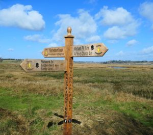 Here you will find a new signpost, erected to indicate the way of the new King Charles III Coastal path, a 2,700 mile National Trail developed by Natural England to become the world’s longest managed coastal walking route – history in the making.
To your right you see the broken river wall, breached, we think, in the second world war. The house, Cross Farm, is close to the current northern boundary of Waldringfield and there is a field close to it known as Preston field. This was the parish of Preston. It is not known if the farm is Cross Farm because it was occupied by one Farmer Cross in the 17th century or whether there are religious reasons.
Over the water is Methergate with its deep jetty and further upstream on the right in the trees is Sutton Hoo, barely four miles away. In the distance, standing proud since the 1500s is the tower of St Mary’s in Woodbridge, possibly built so tall so as to aid navigation. When I photographed it for the book it was shrouded by tall trees and was barely visible. I cleared some of the trees digitally but since then they have been dealt with properly and the tower is, once again, clearly visible.
The walk now takes you along the along the river wall which was raised slightly following the flood of 2013. At the same time the stream behind the wall was moved away from the wall and further on you will see that it has been made into a nature reserve.
In 1348, here you would have been walking on water.
Even twenty years ago there was a lot more scrub than there is now and Waldringfield did not become visible to the walker until much further along the wall.
STOP 8: The River Wall
Construction of the river walls probably started in the 1400s, nearer to Alderton and Bawdsey. It is likely that the parish churches of both were close to the water’s edge before the building of river walls. The mouth of the river would have been very much wider and in 1348 there was a busy port at the mouth known as Goseford.
The river walls in our neck of the woods were constructed later – probably in the late 1600s /early 1700s even, but nobody can be sure.
The Fairway
From this part of the walk you have a good view of the Waldringfield Fairway extending from Methergate in the north to Early Creek, opposite Shottisham, in the south. There are 211 moorings in that Fairway and since 1938 they have been administered by the Waldringfield Fairway Committee. As an elected non-permanent body the Committee is not allowed to lease the foreshore and fairway from the Crown Estate to which it belongs, so the Committee appoints four permanent Trustees who hold the lease on its behalf.
In the winter there are only buoys, birds and weather. In the summer there is an air of unhurried leisure and freedom – freedom to escape in a simple boat. The mud and the marshland are full of activity. The woven dams are relatively recent – put there to try and recreate the marshland – interestingly, not unlike the fishing methods of the Anglo-Saxons.
Ahead you may or may not see the island, depending on the state of the tide. It is frequently submerged at high water. The island has formed over the last two centuries.
STOP 9: The John Waller Nature Reserve
As you walk along the river wall you will see, coming into view on your right the northern end of the Nature Reserve set up following the flood of 2013.
When Reverend John Waller died in December 2013 he left this parcel of land for this purpose. Behind it is Grove Field, the majority of which would have been under water in 1348. Sandy Lane, to which I referred earlier, passes from your right to your left on the other side of this field.
Your imagination may be taxed as you pass the Waldringfield end of the Nature Reserve because, in the late nineteenth century and the first decade of the twentieth, the vista ahead would have been completely industrial because of a Cement Works. Indeed, the very air would have been fairly rank from the smoke rising from two or three factory chimneys and twelve bottle kilns, marked on your map with a ‘K’.
The Cement Works
If you can imagine an industrialised Waldringfield you will be transported rapidly from the relative peace and tranquility of 1348 to the noise and the smoke of 1878; ahead of us there would have been rows of cement kilns. One row of four to start with, then two rows of four and by 1902, three, thus making twelve kilns in all.
The industry went back to 1860 when there was just one kiln, producing roman cement, such as one might find in any small village, but there were changes afoot in the cement industry and it was George Mason, an Ipswich industrialist and barge owner who set up a Cement Works to produce Portland cement (2 parts chalk to one part mud) on the site. There was plenty of mud in the river– bed and the chalk could be barged up from the Medway on his own barges.
The majority of the mud was dug from Early Creek to the south of the village using a narrow barge called the Kingfisher, skippered by one Jack Stebbings
By 1904 the works included twelve bottleneck kilns but by 1907 it was all transferred to Claydon where the soil evidently possessed all the necessary constituents.
The Works were extensive, stretching from the first building you pass on the river wall to the Old Maltings (see Stop 11) next to The Maybush, and inland beyond Deben Lane, almost to Sandy Lane (see ‘K’ and the sketch of kilns on your map). That first building, now a single house, was probably semi-detached originally; it included the factory manager’s house.
The dotted line by the sketch of the kilns was a footpath from the river wall to Sandy Lane. Just to the left, or west, of ‘K’ is Deben Lane which started life as a simple walkway through the Works. Please note that the said footpath no longer exists except from the end of Deben Lane to Sandy Lane.
STOP 10: Riverside dwellings, the Boatyard and the Coal shed
Immediately following the factory manager’s house, your path along the river wall takes you past six dwellings of different shapes and sizes which reflect more recent Waldringfield – the Waldringfield of rest and recreation, described in our book as a walk in 1971. Behind these are six more and the whole is known as ‘The Quay’ or Quay Lane.
As you walk you will see ahead the boatyard and its jetty. In the days of the Cement Works this area was all part of the industrial estate. The industry ceased in 1907 but it was not until 1925 that the quayside changed ownership and became Ernie Nunn’s boat building business.
The path takes a sharp right just before the boat-shed and delivers you onto Quay Lane. This is Stop 10. Directly ahead, behind the house called ‘Waterside’ there was once a row of four kilns To your right is the aforementioned ‘Quay lane’ which is private. Behind two of the houses along there on the left there were two rows of kilns, four to each row. One of the bases remains intact and demonstrates clearly the ‘no fine’ concrete which was being used for buildings in this village at that time.
‘No fine’ concrete is a mixture of shingle and cement – there is no sand involved. The result is a strong impenetrable mix which was used, at that time, only here in Waldringfield and on Queen Victoria’s Osborne estate on the Isle of Wight.
Turn left from Stop 10; you will pass between the boatyard and the Coalshed. Originally part of the Cement Works estate, the Coalshed has a floor of compacted chalk. The machinery of the Works used an immense amount of coal and the maltster, John Hill, who lived in The Maltings, was also a coal merchant, so it had good use as a store for coal. Now it is a boat and mast store. Note how the land around it appears to have risen over time as the lane has been resurfaced.
STOP 11: The Maltings and The Maybush, Cliff Road and Cement Cottages.
The Maltings, sometimes called the Old Maltings, was built at the very beginning of the nineteenth century and may be seen on an 1805 map. Its third storey has the appearance of being an upward extension but it is original. The house was built for the purpose of malting barley, the third storey being essential for preparation of the grain.
The house was known as Cliff House in 1861 when the census showed that it was occupied by Arthur Thomas Cobbold, the youngest son of John Cobbold of Ipswich brewing fame and Harriet née Chevallier (of Aspall and cider fame).
Arthur owned the property and lived here with his lifelong partner, Sarah Elliston with whom he had ten children. They were able to marry once his parents were no longer in a position to object ie deceased!
John Hill and his sons became the maltsters here, as tenants, for three or four decades until at least 1901. They were also coal and grain merchants. In 1877 the house had been bought by George Mason, about the time that he was expanding the Cement Works. There have been several owners through the twentieth century including the aforementioned Judge Stinson and his wife. Dirk Bogarde was a visitor here in post war days when it was owned by Mrs Edith Jones; her eldest son, Jack, was a yacht designer, occupying the top floor and her younger son, George set up a yachting agency in the coach house at the back.
There is a tunnel between the cellar of the house and the cellar of the Maybush. An entrance is clearly visible at each end, but it is now definitely blocked in its mid-part
The Maybush, across Cliff Road from the Maltings, probably started life as a farmhouse/ home for the ferryman who would row the ferry to and from Stonnor Point. It is quite possible that the central core of the pub (the main bar area) was built in the fifteenth century. There are small Tudor bricks (15th century) in the wall but, of course, they could have been recycled from an earlier building.
The pub has had various names; Cliff Inn, The Bush, May Bush and now The Maybush. It was first licenced circa 1745.
George and Caroline Hunt have a tenancy record of 48 years to 1904. They had eleven children in 21 years and Caroline (widowed for the last 13 years) ran a tight ship – she had to because she was dealing with coproliters, bargemen and cement workers – all rivals, all ready for a brawl.
Cliff Road and Cement (Concrete) Cottages
Cliff Road separates The Maybush from The Maltings and leads up the hill away from the shore. You will see to the right of the road a line of cottages. Three terraces, each with four four dwellings. These are known as ‘the Cement Cottages’ although strictly ‘the Concrete Cottages’ would be more accurate. They were built in the late 1800s to accommodate mainly workers in the Cement Works and their families. As with the kilns they were built with ‘no fines’ concrete ie shingle and cement with no sand. The mix would be poured between wooden shutters. The walls are very solid and residents complain that drilling into the walls is next to impossible.
On that note you are reminded that if you need refreshment now is the time to take it before leaving the Maybush behind.
Emerging from the riverside door of the pub go down the steps and turn right onto the path which leads to the shore, walk along the beach, past the harbourmaster’s hut, toward a raised ‘path which takes you past the sailing club.’
If, by any chance it is high water with a spring tide the water may prevent you walking on the beach without appropriate footwear – barefoot. In that event it is suggested that you go up into the car park and into the sailing club car park in order to access a path and steps which will take you down to the ‘path that takes you past the sailing club.’
STOP 12: Waldringfield Sailing Club and the Beach Huts
Waldringfield Sailing Club was founded in 1921. By 1924 there were 19 members and now there are about 700. The Cement Works had gone, the war was over and, altogether, the place was just right for leisure boating. A comprehensive history of the Club has been published recently. (2025)
The first Committee Meeting of the Club was held in a round ex-Army Nissen hut called Gorse Cabin which is the first beach hut past the clubhouse. The first clubhouse was also a round Nissen hut. Obviously, the clubhouse has been renovated, replaced and extended over the years, the last extension having taken place in 2013.
It is thought that there have been huts along this part of the shore since 1895. The oldest lasted until just after 2016 when it was replaced. The Nissen Hut at Gorse cabin has long since been replaced but part of the modern roof derives from offcuts of the roof of the Millennium building at Wimbledon.
You may note that some of these huts are quite extensive in size and that behind them there seem to be ‘platforms’ in the cliff face. This part of Waldringfield Cliff was dug for coprolite.
STOP 13: Operation Quicksilver
You are standing now in the WSC dinghy park. Note the thick low walls of concrete. These date from the second world war when the beach was off limits to all except a few military officers and a trusted civilian. There were obstacles of concrete and metal on the beach, and mines in the water.
Each night for several weeks 3 fake barges, known as Big Bobs, were built of scaffolding and canvas and floated on to the river until a fleet of sixty could be seen from the air, moored up in pairs. It was also a training area for similar exercises elsewhere on the coast. It was all part of the operation to deceive the Germans prior to D-Day.
STOP 14: Church Creek
Turning inland from the dinghy park avoid the temptation to turn left on to a signposted footpath – unfortunately it takes you nowhere except to another breach in the river wall. Instead, go further inland, through a formal gap in the fence and on to a path alongside a reservoir.
This reservoir was constructed in the 1960s and provides much needed water for the local farmer in the summer.
At the western end of the reservoir the path of the history walk turns to the left but before going in that direction I suggest you go straight ahead, alongside a pond until you reach a gate marked ‘private’. Before the river walls were built this would have been a significant creek going up to just below the Church. In Anglo-Saxon times it is likely that there would have been a water mill in here.
It is very likely that heavy stones for church construction were brought here by boat and lifted up the cliff – window stones and the font for instance.(see Stop 17)
Now retrace your steps to the intended path and turn right on to it. The walk now takes you over two fields
STOP 15: White Hall
As you walk across the fields admiring the view of the Deben and imagining that there may have been Romans hereabout (bearing in mind the fragments of Roman roof-tiles which have been found on occasions) the roof of White Hall will gradually come into view. You are approaching the back of the house. It is, of course, better appreciated from the front which you will reach if you follow the footpath round to the long drive.
In 1830 George Waller, son of Thomas Waller of Ramsholt, came across the river with his new wife, Anne. She had been living with her parents at Wood Hall in Sutton. They came to White Hall which had been a family farm for the Waller family since the mid 17th century. It was a busy farm with several barns. The house itself was built in the mid 18th century.
The couple had two children -Thomas Henry b 1832 and Georgiana b 1834. Unfortunately, George died in 1834, so Anne returned to her parents at Wood Hall with her young children.
Thomas Henry would return to Waldringfield as its new Rector in 1862.
The house was sold out of the family in 2013 and renovated. The barns had fallen into a state of disrepair several decades earlier and had been demolished.
STOP 16: Plum Tree Cottage
Once known as White Hall Cottage, this delightful cottage found fame in an Anthony Horowitz TV play. Note the lovely barge boards.
This is a suggested stop because it gives a chance to appreciate unspoilt Suffolk. The lane leads in one direction to Newbourne and, to your right, back to Waldringfield via Church farm and the Church. The formal track to your left leads to Hemley Hall and, for a walker, the hamlet of Hemley.
Diagonally opposite Plum Tree Cottage there is a coprolite pit, guarded from the corner of the lane by Mirabelle plum trees.
Aerial photos suggest the possibility of there having been a Roman villa, beyond the pit on the left of this road toward the Church.
The road toward the Church is narrow with barely room for a car to pass a walker so I advise against dallying!
STOP 17: All Saints Church
Needless to say, this is the oldest surviving building in the village. It is a stone’s throw from the site of the Hilton Manor House which is where Church Farm Cottages stand now.
There is a 13th century window to the left of the porch which suggests that the building dates from that century. The stone was probably lifted from a vessel on the water in the creek below, which we visited earlier.
It is likely that there was a place of worship on the same site in pre- Saxon times, small and probably built of wood. A bronze-age burial urn was dug in the Churchyard in 1841 which suggests that the site may have been a burial place before the Anglo-Saxons began converting to Christianity.
There have also been Iron age finds in the churchyard which are now in the British Museum.
The red-brick tower was built in the early 16th century. The brick work is Tudor.
In 1862 when Rev. Thomas Henry Waller was instituted the church was in a ‘ruinous’ state
The Church was closed for refurbishment in 1865. The project was paid for mainly with funds gained from selling Coprolite to the expanding fertiliser industry.
From the Church, turn right into Mill Road.
STOP 18: Mill Road
The first house on your left was once the house associated with a post-mill, driven by wind catching its large sails.
1n 1891 Mr Buttrum, the then owner, put both the house and the mill up for sale. The mill was once described as a landmark ‘visible for miles around’ but it fell into a state of disrepair and was demolished circa 1910.
Archaeological artefacts have been found in the fields to the left of Mill Road
Follow Mill Road to its ‘T’ junction with Cliff Road. Then turn left.
STOP 19: School
The village school is on your left as you progress toward the Village Hall. Ironically it is not a good place to stop! However, it is worth stopping to look at it from the parking spaces outside the Village Hall. Once again, looking up, you can see distinctive barge boards (and swift boxes)
The school was built in 1874, replacing the small school-house which you saw at ‘Stop 3’. Once again, the project was paid for with ‘coprolite money’. It proved a good investment as the rapidly developing Cement Works provided plenty of customers.
STOP 20: Village Hall
We hope you have enjoyed the Waldringfield History Walk. You are now back in the car park at the Village Hall which was built in the year 2000 with money raised by village residents and many people associated with the village, together with a substantial millennial lottery grant.
GT 2026
To download a pdf copy from the website scan the QR code.