Maps and Charts of our Locality and River for comment
Merged with Charts
I am told there are people who do not care for maps, and I find it hard to believe.
For the benefit of future local historians and to feed those afflicted with curiosity, the relevant maps and charts we have found and used are listed here. For our book, we have regarded maps as dealing with the land and charts with the water. They are reproduced here only as small images to give a sense of content as we could not do them justice. Some are available by consulting the Book Notes on our website. If the reader has or is aware of, other relevant charts or maps our group is eager to learn of them.
1360 Gough map of Great Britain. As one would expect this does not show our village. See www.goughmap.org
1576 Christopher Saxton: County Scale, shows Waldringfeld. Rivers are interesting. 1)Saxton map also at British Library
1659 Suffolcia vernacule Suffolke: by Joannes Janssonius at the University of Utrecht 1:240 000: Large Scale and in English Shows Waldringfelde, the rivers are interesting as is the coast at Orford and Felixstowe. Available Online.
1611 Speed map of Suffolk: County scale, shows “Waldringfielde”, Brightwell river and Fynn river. No river to Shottisham
1722 Robert Morden map of Suffolk: Large scale, no relevant detail, distance scales interesting, not available online.
1783 Hodskinson’s map of Suffolk: Large scale, some relevant detail. Shows Rivers Hall and Chilton Hall. We believe “Chilton” to be a copying error from extravagant writing of “Hilton”. This may be the map that started this.
1796 Vernon Chart Large scale, strong contour shading. Note Stoney Point, sea wall to the south but not north, no walls at Shottisham side. Otherwise does not show much new. A letter from Survey Superintendent, William Mudge, dated 11 October 1820, reads: “Mr Stanley is going with me …to Woodbridge to examine what is necessary to be done with Mr Verron’s Plans…I apprehend they are much worse than… I expected.” An interesting coincidence that a Mr Stanley is involved (see 1845 Deben survey).

1796 Vernon map clip from British Library
1800 Isaac Johnson map: No scale. This shows how Sandy Lane was referred to as “Leading to the Street” which was and old name for Fishpond Road. Note also how Church Path continues directly from today’s Sandy Lane without a dogleg (houses now occupy the old position). The status of the Northern part of Mill Lane is unclear. Deben Lane does not appear. On the 1829 Glebe map Mill Road is called “New Road” – we don’t know when the Wind Mill was built. Little change in the 1842 Glebe Map although Mill Road North is inked in. The line of Church Path fits with a large shadow on 1945 aerial photos. Note how the road veers to the west from the Church and stops – did Mill Road, if it existed, take a different route?

I800 Isaac Johnson. Map
1805 Map No. 169, Ipswich and The Naze, in the Cassini Historical Series of old Ordnance Survey mapping of England and Wales at 1:50,000 This may have been based on the 1783 Hodskinson’s map of Suffolk since it repeats errors. This is not a very detailed map and may have been prepared from earlier maps. It shows “Chilton ” Hall, probably a copying error from an extravagant “Hilton” in an earlier map.
1829 Glebe (related to the Church and not covered here) map: No scale. This looks like an Isaac Johnson map. Note the river is referred to as ‘”The Ocean”.

1829 Glebe map

1839 Tithe Map
1842 Glebe map: No scale. Note the subdivision of fields in Church Lane.

1842 Glebe map
1845 Deben survey (CrossRef) shows much better land detail than most earlier maps found to date. There may well be maps used to construct this chart which have not yet come to light although it has similarity with the 1837 Colby Map. Both of these have contour shading for terrain rather than contour lines. This practice continued until Ordnance Survey maps of the later nineteenth century. Depths are shown as spot readings rather than shading. The use of the contour lines to which we are accustomed today was pioneered by Charles Hutton, a British mathematician whose ambitious 1774 survey set out to measure the mass of a mountain. It took nearly a century to adopt this excellent innovation. Hutton may have adopted the idea from that great sailor Sir Edmund Halley, who used a similar technique in the late seventeenth century. 4)Sir Edmund Halley mapped magnetic declination and invented isogonic lines
1881 OS map guide to Parish: Not all pages were properly scanned but of some interest. (Website notes)
1881 OS 25″ series is the earliest found at a large scale.
1902 OS 25″ and 6″
1907 OS 1″
1919 OS 1″
1925 OS 25″
Ordnance Survey. The maps discussed are available for our area. There are more modern ones of course. Links to these and others are on our website. The National Library of Scotland has a large collection of OS England maps. There are facilities to compare different maps side by side. Note: 25 inch is 1:2500 scale – most detail, 6 inch is 1:10560 scale.
In recent years the Ordnance Survey has made some of its data available online. This data has been used in developing some of the maps shown in our book.
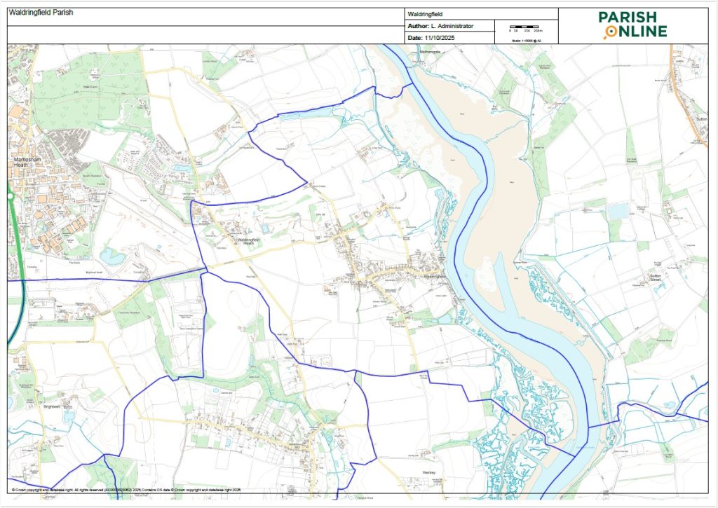
Waldringfield new Parish boundary 2019
2019 Parish Boundary: The official 2019 footpath map has a confusing Parish Boundary with a more southerly northern boundary and bulge at the Heath. Both maps courtesy of Suffolk County Council.
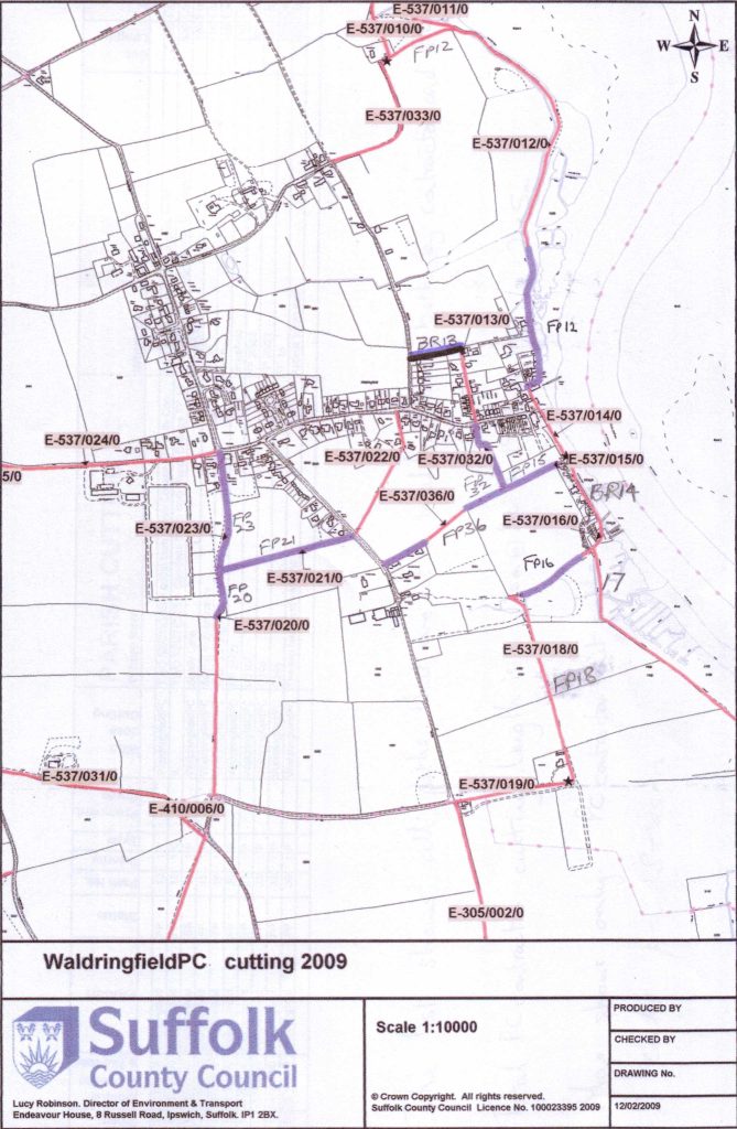
Official Footpath map of Waldringfield
The official footpath map for Waldringfield before the new King Charles III Coastal Path
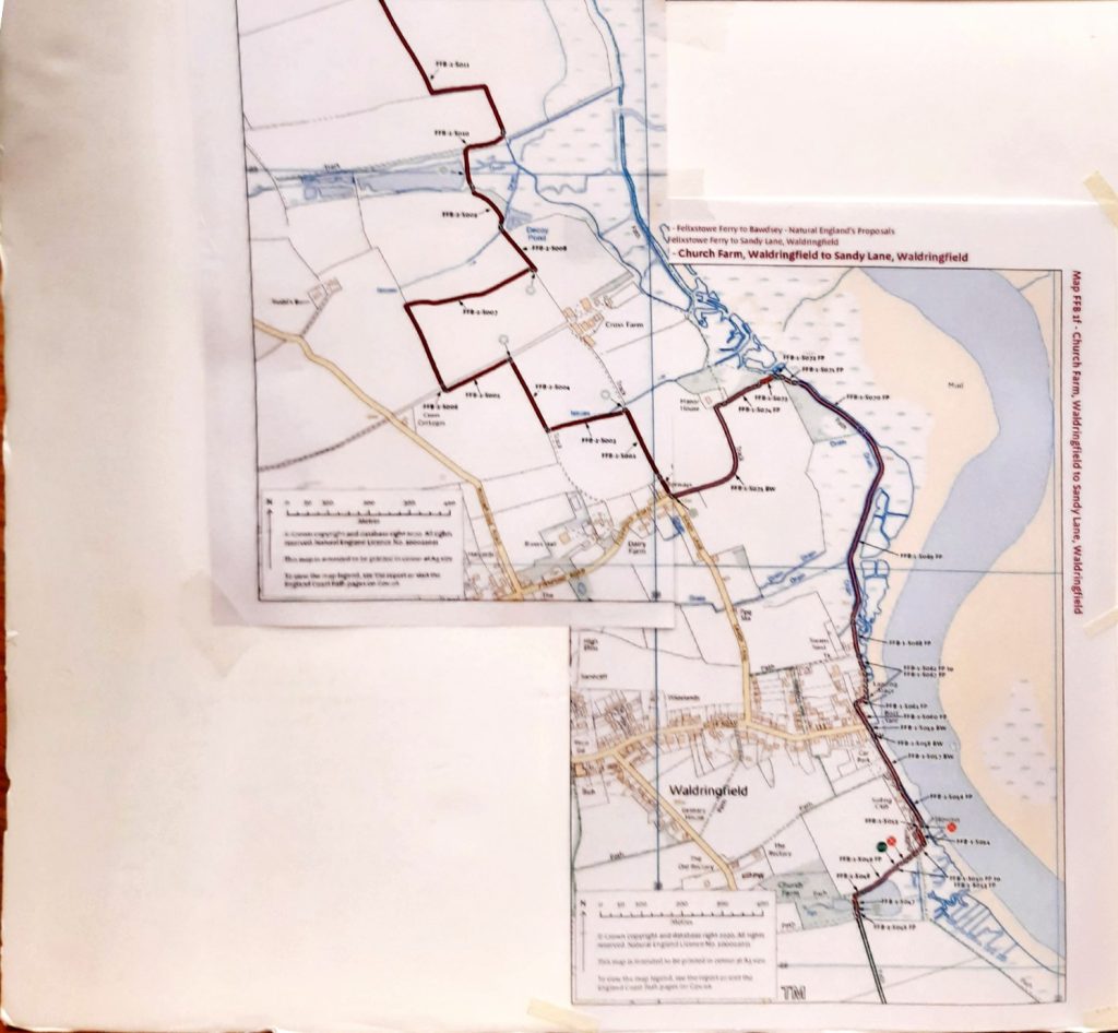
The new King Charles III route through Waldringfield
The new King Charles III coastal path route through Waldringfield
An Historical Atlas of Suffolk is a useful resource. 5) An Historical Atlas of Suffolk – Suffolk Heritage Explorer.
No Enclosure maps have been found to date. Other sources worth a mention:
- 1941 1:25000 German High Command (there are also Oberkommando photographs of the Deben but not of the village).
- 1945 Google Earth Timeshift has good aerial reconnaissance photos of our area.
- This was a military area so there are some good wartime reconnaissance photographs with more detail.
- 1969 Soviet Military maps are available but show nothing of interest.
During the 21C LiDar data showing land elevation has become publicly available and has been used in some of the maps in our book. There are also Aerial Photograph tiles taken at Low Water which are superior to Google Earth. See our website DEFRA LiDar Data and sea levels for mapping.
For general information about maps see A Short History of English Maps There are also maps and lmap inks on our website.
References
-re Isaac Johnson map – last sentence – comma after ‘existed’
-re 1805 map – capital H for Hall
-re 1829 map – Change to ‘Note the river is refered to as ‘The Ocean’
-re 1824 map – fullstop not comma after Maybush
-re 1839 map- first two commas should be full stops followed by Caps
-re Ordanance Survey – full stop and Caps not comma in first sentence
right at the top – 1576 map – “Waldringfield” is spelt wrongly as “Waldringfeld”
– 1611 – Waldringfield has been spelt with an “e” at the end of “Waldringfielde” unless these are deliverate to copy original spelling
– I think this phrase is extra but needed – possiblity”the field numbers on this map cross refer to the Apportionment”.
-1800 Isaac Johnson map: I am afraid that I cannot see ” This shows how Sandy Lane was referred to just as “Leading to the Street” which was Fishpond Road” has it been missed from the picture?
– above the 1876 map “an odd subdivision of fields in Church Lane.” not sure about this. are you commenting about the bit opposite Nova Castria? or where in Church Lane. I rather think that Joe told me that a piece of field had been swapped for a bit of Glebe – will need to check with him
Just one item to point out:- “1969 Soviet Military maps are available but show(n)” delete “n”.
Interesting chapter but not sure how clear the maps will be if printed in a book. I struggled to read them on a big computer screen. I am not sure what you mean as “An odd subdivision of fields in Church Lane.”? These marked fields are those that belong to the Rectory and presumably were given as a selection as Glebe. Historically that might have given the rector a variety of different fields suitable for his different uses? Werent they supposed to supply him with food or something. “Glebe (also known as church furlong, rectory manor or parson’s close(s)) is… Read more »
All comments noted